Energy Solutions
Events

Precision Mapping and Survey

Precision Mapping and Survey

Our company, Anton Solutions, provides precision mapping and survey services tailored to diverse industries. We specialize in advanced drone technologies, specialized equipment, and expert techniques. Our solutions capture high-resolution, accurate geospatial data to support efficient project planning, resource management, and decision-making. We help businesses achieve greater accuracy, reduce operational costs, and improve productivity with reliable mapping services designed to meet specific project requirements.

Drone Technology Applications

We use advanced drones to collect accurate data efficiently. Our drones cover large areas, reach difficult locations, and capture high-quality images for precise mapping. They operate in diverse environments, including rugged terrains and remote regions. This technology reduces manual efforts while improving data consistency.

  • Fixed-wing Drones: Cover wide areas quickly. They are ideal for large surveys with extended flights, reducing costs and improving overall data collection accuracy.
  • Multirotor Drones: Provide great stability. These drones are perfect for mapping tight spaces, rough terrains, and hard-to-reach locations with precise data accuracy.
  • Hybrid VTOL Drones: Combine vertical takeoff with long-range flight. They are suitable for flexible mapping tasks and have consistent, reliable performance.
  • Feature image
    Feature image

    Survey Techniques

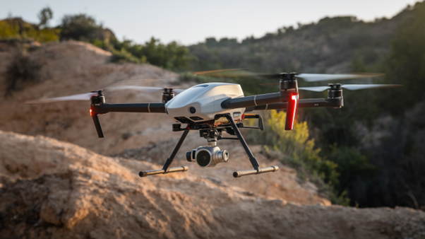
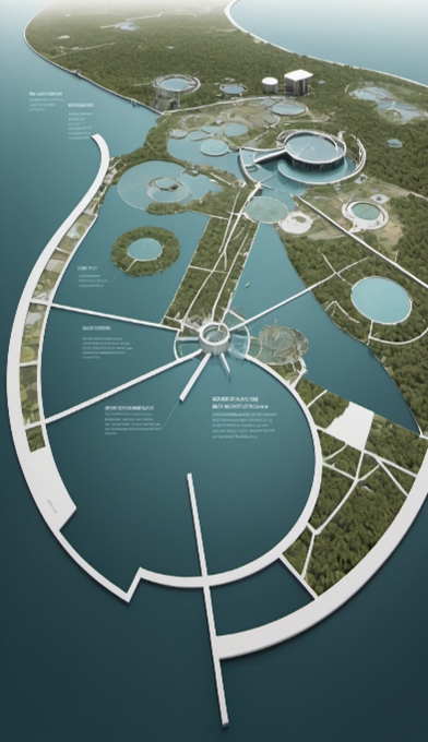
    Anton Solutions applies precise techniques for mapping and surveying. These methods improve data accuracy, deliver high-resolution images, and support detailed project analysis across different terrains and environments. Our advanced tools enable faster data processing, reducing project timelines. This ensures efficient, accurate, and cost-effective survey solutions.

  • Photogrammetry: High-resolution drone images are captured to document large areas. These images are processed to create detailed 2D maps and 3D models for accurate terrain analysis.
  • LiDAR Scanning: Laser pulses measure distances with precision. The data generates accurate 3D maps, ideal for dense forests, rugged terrains, and complex infrastructure projects.
  • GIS Integration: Spatial data is collected and managed systematically. This enhances mapping accuracy, improves resource planning, and supports environmental monitoring and urban development effectively.
  • Advanced Survey Tools

    High-Resolution Cameras

    Capture sharp, detailed images for topographic mapping and orthomosaic creation. They provide clear visuals essential for accurate project analysis and planning.

    Thermal Sensors

    Detect temperature variations to monitor environmental conditions. They are highly effective for inspecting infrastructure, identifying heat loss, and assessing equipment performance.

    Multispectral Sensors

    Analyze vegetation health and land conditions. They help track crop growth, detect environmental changes, and support land-use management with detailed, multi-band imagery.

    Background Image

    Applications Across Industries

    Resources

    Gain clarity through detailed reports, strategic perspectives, and insightful white papers. Discover data-driven approaches influencing modern mapping and survey methodologies.

    Brochure Box

    AI-driven drone analysis helps optimize resource planning with accurate volumetric measurements and asset evaluation. Discover more—download the brochure now!

    Product Image

    Asset Estimation

    Anton Solutions provides drone-based asset estimation, volumetric analysis, and AI-driven insights for resource planning. Download our brochure to learn more.

    Download
    Product Image

    Data Processing

    We transform drone-collected data into actionable insights, ensuring accurate asset tracking, analysis, and reporting. Get the brochure for full details.

    Download
    Product Image

    Equipment

    Our company uses high-tech UAVs, LiDAR, thermal sensors, and imaging tools for advanced asset assessments. Access our brochure to see the technology.

    Download
    Product Image

    Infrastructure Inspection

    Drones inspect bridges, power lines, and structures, preventing failures through high-resolution imaging and analysis. Grab your brochure copy today.

    Download
    Product Image

    Mapping and Survey

    High-accuracy aerial mapping and surveys provide detailed topographic data for construction, mining, and land assessments. Learn more by downloading our brochure.

    Download
    Product Image

    NDT (Non-Destructive Testing)

    Our UAVs perform non-invasive testing, detecting material defects, structural weaknesses, and safety hazards remotely. Download the brochure for insights.

    Download
    Product Image

    Digital Eye

    Anton Solutions uses drone-mounted cameras for inspections, surveillance, and high-precision data collection. Get the brochure for full details

    Download

    Technology Videos

    Watch our latest technology-related videos and explore new innovations!

    Related Insights

    OUR PARTNERS

    By building powerful partnerships, we promote growth, drive bold solutions, and create meaningful change through collective collaboration. Every connection strengthens our purpose.

    Document